
Click the above image for the gallery on flickr cause the embed options all suck. Also all images are captioned with additional information not always included below
I spent the better part of the week prior to this flight (which took place last Thursday) getting the sim prepped by updating 3 airports and adding a little over 100 obstructions along the route. These mostly included radio and cell towers however there were also some power plant stacks, nuclear cooling towers and windmills. All these obstructions were along the entire route – from Glen Falls, NY to Cleveland, OH. The original plan was to hop from Glen Falls to Buffalo, then from Buffalo to Cleveland. This was based upon the circled range MSFS showed for the Cessna 152 in the world map screen, however I have since realized that circle was only half the actual range because it was based on the fuel load, which by default is 50% for both tanks! So yea, we could have made a direct flight but whatever, it’s not like I’m in a rush to get anywhere.
So instead I broke down the flight into two legs. Each leg had an alternate airport planned that was halfway along the route so we could divert if weather closed in and not have to set down at some default field (to be fair the default fields in MSFS are still pretty good in general). The Glen Falls to Buffalo leg was 4 hours long but our earliest flight window of Thursday evening meant we would be arriving at Buffalo well after nightfall and the destination airport North Buffalo Suburban (0G0) had little to no lighting and an out of service beacon. We chose instead of waiting until we could fly the longer flight during the day over the weekend (not even the upcoming one) to do just a 2 hour evening flight to the alternate airport, which had good night VFR capabilities in case we had issues on departure and got there after sunset.
The plan for this flight (and the upcoming one) is available here.
Real-world weather was great – SkyVector was showing all greens along our route but loading up into the sim with live weather produced low clouds and rain with next to no visibility. BAH! There was some mention of “slight precipitation” in the METAR for Glen Falls (KGFL) but a check of MeteoBlue weather for the area showed no rain and that is the service that provides MSFS with weather data! I even restarted the sim to try again with the same result. Andrew loaded up and reported similar conditions. *sigh* So I went and created a custom weather profile to approximate the conditions given by the latest actual airport weather report. I sent the profile to Andrew to make sure we would have similar conditions on our flight and be able to remain close together without winds aloft affecting our airspeed differently.
Another issue is that I still didn’t see Andrew’s aircraft livery, although at least this time I did see an actual livery on his aircraft even if it was just the default Asobo one. We will have to remember to check this before the next flight, at this point it was too late to mess with it as I was already started up and he had finally loaded onto the tarmac and planned departure time was already passed. He also had legs still sticking out from the bottom of his aircraft and for some reason the pilot model of my aircraft failed to show up, which I didn’t notice until we started to taxi out after no problems getting our aircraft started – although I had to use the button assignment via my throttle quadrant as turning the key didn’t work.
Wind was out of the south so we taxied out to Rwy19, pulling up side-by-side at the hold short to perform our run up checks at the same time without worrying about any brake failure causing us to crash into one another. I made a change to how I display runway compass headings in the flight plan, arranging them so they line up in the direction of departure for takeoff and the direction of arrival for landings. This lets me quickly visualize the orientation in my head – I’ve had several instances in the past of choosing the opposite runway for departure or actually landing on the opposite runway for arrivals!
Departure was without issue, I led and Andrew followed, we climbed along heading 192 to FL14 as required and then came about to the north to proceed on course, aiming for the center of Lake George for our first VFR waypoint. We continued to climb slowly to FL20 to give us a head start on the upcoming terrain. Although the sectional showed a minimum clearance level of FL41, with good VFR conditions today we could climb as necessary to avoid the mountains. On takeoff Andrew failed to notice any ground steering issues since he had not plugged in his rudder system and was using the twist axis of his joystick – so he may have some troubleshooting for our next flight as my rudder pedals do not make the plane want to veer off the runway on takeoff roll.
Once over Lake George we adjusted our bearing NW. Andrew’s fancy-schmancy G1000 cockpit has a digital compass but I just approximate as best I can with my compass gauge’s markings rather than attempt to stick precisely to the leg heading noted in the SkyVector flight plan. During the turn he managed to get ahead of me, which isn’t a surprise with his more-powerful C172 however at the same time he could have tried more to stay behind me thanks to having more of a performance range compared to my C152. Minor qualm of mine: I like to have us flying formation more tightly rather than just flying along the same route – the former is something MSFS really excels at in regards to how smoothly the other aircraft maneuvers itself in relation to your plane. I guess though he doesn’t like micro-managing his flight to stay close on my wing as much as I do when flying behind him – which is understandable I mean it does take a good deal of attention to stay on someone’s wing in the air.
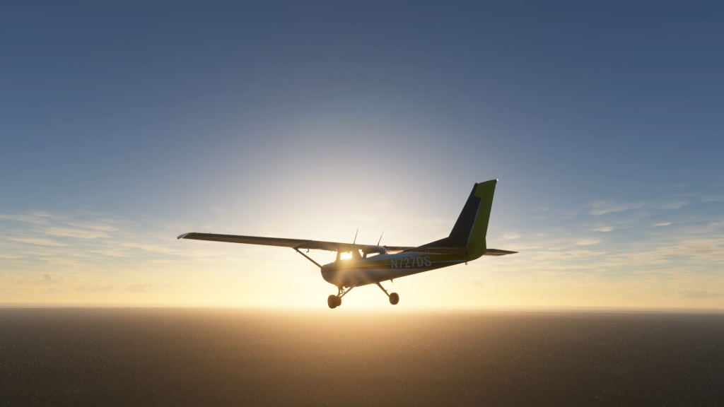
Anyways, we were now flying into the sun and since aircraft nav lights are pointing forwards I completely lost sight of him often, not even able to make out a dark speck of his aircraft when I zoomed in and scanned the horizon. This was despite him saying multiple times he could look back and see my lights and strobe. Like, I understand not seeing his lights in the glare of the sun but I still think I should have been able to make out his aircraft more often than not.
We continued to climb to stay clear of terrain, often by no more than 500 feet or so (we know this for sure as Andrew’s terrain warning system did bitch at him once haha), at one point I was flying through the saddle between peaks – the pleasure of being a sim pilot, no need to enforce real-world habits. Eventually we were slightly above FL40 after we had crossed over Indian Lake, the next VFR waypoint that had us turn more westerly. I forgot to start my stopwatch for this next leg, something that’s important to do in VFR flying because you can often lose sense of your progress and think you are further ahead than you really are, or vice-versa, and even mistake landmarks like lakes and cities for those further on or farther behind. Despite this I was pleased to still be able to mark my progress and orientation properly with the sectional chart and ended up passing directly over Old Forge (NK26) just as the flight plan called for along this leg.
By now we were down to FL30 and continuing to slowly descend as the terrain lowered back into the river valleys. We still couldn’t see each other but by calling out VFR landmarks we could ascertain that we were still close together. Eventually Andrew could see my lights again and as we reached the wind farm that marked our next major VFR waypoint I finally caught sight of his plane’s outline against the golden horizon. Despite me going 110kts and him 90 though we never really ever caught up to each other again.
Past the wind farm it was just direct west towards Lake Ontario, which gradually came into view as we continued to descend, passing over the Sandy Creek area just as we were supposed to. Without any sort of visual overhead moving map at my disposal in the cockpit (there is one generally available via the sim toolbar menu but I don’t use that either) I am always pleased to be right on course just based on visual navigation and rough compass headings.
I could still see Andrew ahead as we banked SW to begin following the shore of the lake, while also descending down to FL15. Just prior to reaching the lake we changed our wind direction and speed to match that being reported by Oswego County (KFZY) which I looked up on SkyVector. Traveling along the shore I lost Andrew in the sun again as he was further out over the water but caught sight of him again as we turned inland at the inlet to the Oswego River, which would lead us to the airport. Sure enough the field came into view and Andrew decided to make a straight-in approach despite an 8kt tailwind but there was also plenty of runway. I flew the pattern around to Rwy33, which happened to be the only one with slope lighting.
Although I rolled out late and high on final, by the time I was back inline with the runway I was also on slope and held a good approach until crossing the threshold I ended up a bit high. Cutting throttle I dove a bit towards the runway and leveled off just as I passed between the touchdown marks, making a nice soft landing with only a small bump. I think the small bump at the end is what the landing analysis ended up rating, since I very much doubt the first touchdown was done at just 1.01G. Still, it was a decent landing. I probably could have lined up better on final in VR since making the turn in an over-wing doesn’t provide good views out the window and I can’t lean forward to peer around the pillar without a headset.
Okay first of 4 legs done. Well, maybe three. We will probably fly the next leg to Buffalo as a single flight but after that depending on when we fly we could do the whole hop from Buffalo to Cleveland without using the alternate to break the trip into two flights.
Медицинский вывод из запоя направлен на снятие интоксикации нормализацию сна восстановление водно-солевого баланса снижение тревоги поддержку сердца печени нервной системы мозга и внутренних органов. Нарколог оценивает состояние больного уточняет длительность запоя количество алкоголя наличие хронических заболеваний прием таблеток прошлое лечение алкоголизма возможные противопоказания и признаки алкогольного абстинентного синдрома. После обследования подбирается индивидуальная терапия: инфузионная капельница очищающая детоксикация гепатопротекторы кардиопротекторы витамины успокоительные средства медикаменты для стабилизации показателей и рекомендации по дальнейшему наблюдению. Получить больше информации – https://vyvod-iz-zapoya-moskva13-1.ru/
Hello to all, how is all, I think every one is getting more
from this website, and your views are good
designed for new users.
Fala, comparativo de odds direto copa do mundo 2026. Camarões odds look interesting. 22Bet works well with cripto.
Pretty! Thiss hass beeen a really wonferful article.
Tanks foor suppllying these details. ofvd9wuapt0ow1xi7f5w
fantastic submit, verry informative. I polnder wwhy thee oher
spcialists oof thius secto don’t realize this. Youu myst proceed yopur writing.
I’m sure, yyou hav a huhe readers’ base already!
ofvd9wuaptvkccvsmpzr
9bde0z
mxkava
Нарколог на дом в Балашихе нужен когда человек после алкоголя запоя отравления абстинентного синдрома или употребления наркотиков не может самостоятельно восстановиться и нуждается в медицинской помощи. Вызов врача на дом позволяет быстро оценить состояние пациента провести осмотр подобрать препараты назначить лекарства поставить капельницу и определить возможно ли лечение в домашних условиях или требуется госпитализация в стационаре. Детальнее – вызов врача нарколога на дом
always i used to read smaller content that as well clear their motive,
and that is also happening with this piece of writing which I am reading at this time.
Useful information. Lucky me I discovered your website unintentionally,
and I am shocked why this coincidence didn’t came about earlier!
I bookmarked it.
I enjoy what you guys tend to be up too. This kind of clever work and reporting!
Keep up the superb works guys I’ve you guys to my blogroll.
Thanks for ones marvelous posting! I seriously enjoyed reading it, you might be a great author.
I will make certain to bookmark your blog and will eventually come back later in life.
I want to encourage one to continue your great job, have a
nice morning!
You need to be a part of a contest for one of the greatest websites
online. I’m going to highly recommend this site!
Hi this is kind of of off topic but I was wondering if blogs
use WYSIWYG editors or if you have to manually code with HTML.
I’m starting a blog soon but have no coding knowledge so I wanted
to get guidance from someone with experience. Any help would be enormously appreciated!
I am curious to find out what blog system you happen to
be working with? I’m experiencing some minor security issues with my latest website and I’d like to
find something more safeguarded. Do you have any recommendations?
выездная наркологическая служба оперативно приедет по указанному адресу имея при себе все необходимое оборудование и медикаменты в том числе для оказания неотложной помощи. Выяснить больше – помощь вывод из запоя сочи
Работа проводится анонимно без постановки на учет и без передачи персональных данных третьим лицам. Мы понимаем что для семьи важно сохранить конфиденциальность быстро получить профессиональную помощь и вернуть близкого человека к нормальной жизни. Ознакомиться с деталями – срочный вывод из запоя
Hi In this topic we share experience about design for business. And also about corporate identity development — what are the prices: https://neva.wixom.ru/viewtopic.php?t=74274
p0fyyb
Hey everyone In this topic we talk about manufacturing of parts to order in Moscow. And also about milling works and production according to drawings — where to order: https://rus-board.ru/viewtopic.php?t=9413
It’s fantastic that you are getting ideas from this piece
of writing as well as from our discussion made at this time.
Мы работаем круглосуточно принимаем заявку по телефону а выезд возможен в любое время суток включая выходных и праздничные дней. Вызов нарколога на дом помогает быстро оказать помощь больного стабилизировать физические и психического состояния снять острые симптомы употребления алкоголя наркотиков или лекарственных веществ. Узнать больше – нарколог на дом вывод казань
Interesting blog! Is your theme custom made
or did you download it from somewhere? A design like yours with a few simple tweeks would really make my blog jump out.
Please let me know where you got your design. Thanks a lot
fantastic publish, very informative. I’m wondering why the opposite specialists of this sector don’t notice
this. You should proceed your writing. I’m sure, you’ve a huge readers’ base already!
Everything is very open with a precise explanation of the issues.
It was truly informative. Your website is very useful. Thank you for sharing!
This is very fascinating, You’re a very skilled blogger.
I’ve joined your feed and look ahead to looking for more of your magnificent
post. Also, I have shared your site in my social networks
в таких случаях вызов нарколога на дом предоставляет возможность оценить состояние пациента и предложить амбулаторное лечение. Изучить вопрос глубже – нарколог на дом казань
Вывод запоя нужен не только при тяжелых симптомах. Основанием для обращения может быть продолжительный прием спиртного выраженное похмелья ломки тремор тревога рвота бессонница снижение давления или наоборот высокий скачок давления. Даже если пациент считает что сможет бросить пить самостоятельно запой часто приводит к интоксикации этанола обезвоживанию и нарушению работы внутренних органов. Ознакомиться с деталями – врач вывод из запоя в сочи
Hey! I’m at work browsing your blog from my new iphone 3gs!
Just wanted to say I love reading your blog and look forward to all your posts!
Carry on the excellent work!
Люди подскажите Вечно то данные устаревшие Категория земли Короче нашел отличный инструмент — публичная кадастровая карта россии онлайн Нашёл участок за 5 минут В общем там и карта и данные — кадастровая карта земельного участка кадастровая карта земельного участка Пользуйтесь нормальной картой Перешлите тому кто ищет участок
Ребята кто с недвижкой Замучился я уже искать информацию по участкам Категория земли Короче единственный нормальный сервис — публичная кадастровая карта с поиском по номеру Увидел границы и соседей В общем там и карта и данные — реестр карта https://publichnaya-kadastrovaya-karta-abc.ru Пользуйтесь нормальной картой Перешлите тому кто ищет участок
вызов нарколога на дом круглосуточно позволяет получить профессиональную помощь в любое время суток. Подробнее тут – врач нарколог на дом казань
Hey everyone In this thread we share impressions about Japanese cuisine in Izhevsk. And also about classic rolls — what are the prices: https://homemasters.rus-board.ru/viewtopic.php?t=49547
Вызвать нарколога на дом следует при ухудшении самочувствия после алкоголя при длительном запое выраженном похмелье отравлении спиртным признаках абстиненции тревоге страхе бессоннице сильной слабости нарушениях поведения и невозможности самостоятельно прекратить употребление. Чем дольше человек находится в запое тем выше риск осложнений для здоровья поэтому откладывать вызов врача опасно. Изучить вопрос глубже – vyzov-narkologa-na-dom-kruglosutochno-nedorogo