
Click the above image for the gallery on flickr cause the embed options all suck. Also all images are captioned with additional information not always included below
This past Thursday the weather and our schedules cooperated to finish our travels to Buffalo. Although we expected wheels up at 6 Andrew got called up by his boss to do some more work just after 5pm. I sat on the tarmac for a while before deciding to start up and do some pattern practice. I listened to ATIS and it told me the winds were 19kts – haha WAT. Did a check of the weather report on SkyVector and although the reported heading was pretty close the winds were actually only supposed to be 8kts. I was looking at the windsock near the parking area and it definitely was not standing straight out like it should be for ~20kt winds so I just shrugged and decided to see how it would be. Took off, flew a decent pattern with a better rollout to final and landed. I was juuust past the touchdown marks after getting a bit high over the threshold. Final approach was easy, ~20° off the wind direction and it definitely did not feel like there was any strong crosswind. Checking my landing report (nice and soft, baby!) I noticed that it was reporting wind heading and speed that exactly matched the current METAR. So the sim weather was right the ATIS was wrong! Interesting…
As I was taxiing off the runway just before 6pm Andrew finally showed up so I waited for him to finish getting ready. Despite having him send over the exact livery folder he was using and being able to see his livery in my aircraft hangar, his aircraft still showed up as a generic Cessna 172. Will have to continue looking into that but no time now. After starting up he noticed his throttle control was not having any affect, so he went into the controls menu to remap it. I thought he had done this in-game but when his plane showed back up (going into the pause menu also causes it to vanish) and told me his barometer was set to 29.92 I had a feeling he had instead backed out to the main menu. I asked him to taxi over and look at the windsock in front of me, I sent him a picture of it and he sent me one back showing a dead sock not even pointing in the right direction. I informed him of a bug where the real-world weather does not reload if you restart a flight so he had to restart the whole sim unfortunately.
Flight plan is available here, this is the second leg.
Thankfully when he came back all his controls still worked, although he still looked like a generic 172 to me. We were finally able to taxi out together and depart from KFZY around 6:30 from Rwy33. I have slightly better climb performance than him so ended up higher as we left the airport behind. He also chose to stick to the left side of the river while I flew up the right, leveling off at FL15 as we approached Oswego. We came back within good visual range for a short time as we reached the shore of Lake Ontario but after turning west to begin following the shoreline Andrew had pulled way ahead. Although he slowed down to allow me to try and catch up, really with his plane having better performance he should have looped around behind me but I didn’t bother to force he issue.
Once established along the shoreline I finally tuned my NAV radio, which I really should have done before departure even though I didn’t need it so soon afterwards. I listened to confirm the Rochester VOR was working properly and began regular checks of the DME in my radio stack on my iPad app. Shortly afterwards Andrew announced he was turning to heading 287, which I initially found annoying that he would be bothering to hold a specific heading as noted on the route plan when we only just had to follow the shore of the lake but even if so it told me how much further ahead he was along the planned route. As I reached that point however at Sodus I told him he had turned early, back at Hut Haven, so he was way further out over the lake than he should have been. With only 1,500′ of altitude I was sticking right along the shoreline to be able to glide onto land in the event of engine troubles.
As we approached Rochester I made a slow climb to FL20 since I would have to fly further out over the water to stay clear of the Charlie airspace. Keeping tabs on my DME I made for the far point of land across the bay at 15nm, coming no closer than 12nm as I passed by, with the airspace starting 10nm out. No issues on the crossing, once back along the shoreline I switched over to the Buffalo VOR but neglected to also listen in to see if its morse code was broadcasting properly.
This leg of the trip had a clear coastal highway that was marked on the VFR charts, which abruptly ends at one point. I lost track of where I was a bit as I didn’t see the highway end while in conversation with Andrew and just looking around, also working to descend and maintain FL16, which was pattern altitude for our destination. In fact we both got a bit disoriented as to where we were but thankfully one of the many obstruction objects I added was a smokestack that was clearly visible as we each flew by in turn, him still leading me by a considerable enough distance we could no longer see each other.
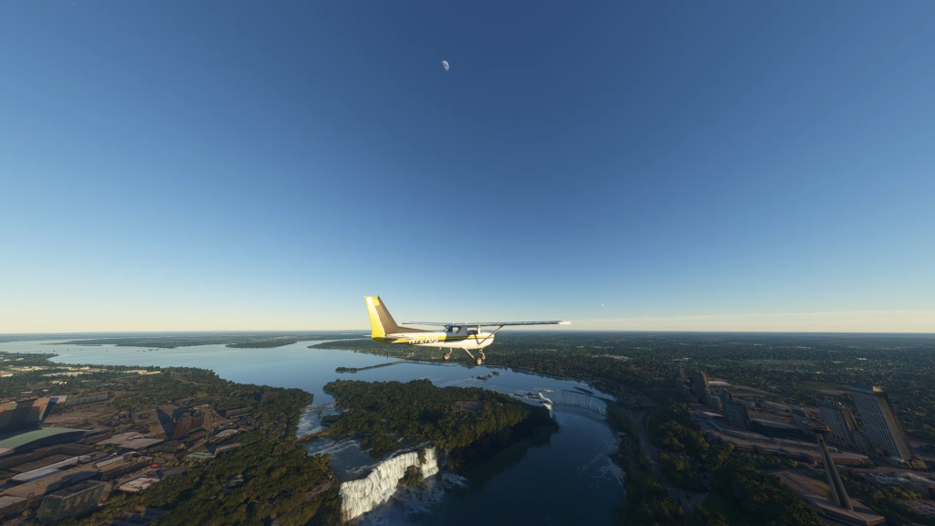
Even though we got a bit lost as to how far we had progressed past Rochester the mouth of the Niagara River isn’t something you can easily miss and we both had no trouble spotting it and following it inland to the falls, threading between the airspace of KIAG and CYSN. Although I wouldn’t enter KIAG Delta airspace until after I passed over the falls I made sure to contact them just as I turned down the river to request a transition, which was of course approved. Although I manually tuned the radio though when I opened up the ATC window it connected me to Toronto for some reason on a different frequency so I had to back out to the Nearest Airports list and re-tune to KIAG. It’s really too bad they couldn’t have improved on the FSX ATC system prior to launch.
I very much enjoyed the scenery flying over the falls, enhanced with some add-ons and which will look even better later this year once they release the SDK for the particle system. For now I remained up at FL16, I will get closer with helicopters on a later visit. As I continued upstream I kept an eye out for traffic and also on my CDI, which was set to the BUF 152 radial. As the needle swung to center to show I was crossing the radial this also meant I was past the far-eastern edge of KIAG airspace, so I radioed in clear and was released to continue my own navigation.
Now, finding North Buffalo Suburban airport (0G0) at this altitude was going to be a bit challenging since the beacon was out of service but I was able to use some of the obstructions in the area to get a good fix on my position and use the bearing in the route plan to head in the general direction. Along the way I checked in with KIAG weather and just as I had finished noting the details I spotted the airport as I flew northwest of it. Whoops! Wrong side! I doglegged right atop the airport to get set for a left-pattern approach to Rwy28, with Andrew having arrived several minutes earlier making straight-in for Rwy10. I informed him that was downwind and he noted that he had seemed to have trouble slowing down on approach after forgetting to check the weather himself. Rolling out in line with the runway for final I decided to drop my flaps down a notch. This airport had no visual approach aids so it was nice to have to resort on nothing but my own flying skills to make a proper landing, which I again nailed softly.
You can see the whole flight with this Google Earth KMZ.
Overall the flight for me went as planned. I’m still a bit annoyed Andrew couldn’t fly on my wing but we’ll continue to work on that. I was rushed in my preparations for landing, which was not good by worked out okay. Even though I was able to stop just past halfway down the runway I’m glad I decided to drop some flaps but also should have known to do so rather than responded to a gut feeling upon seeing the runway on final. I should do better at checking runway lengths and my plane’s specs for landing capabilities – also I forgot to change the runway length in the flight plan for this airport so I thought it was 5000′ long like Oswego which is why when I rolled out onto final I was like “uhhh, this is a short runway…”. Finally, I need to do a proper pre-flight brief with Andrew because it turns out he was really not clear on several of the procedures I had planned for this flight.
Tomorrow I hope we can make the whole hop from Buffalo to Cleveland!
Reading this brought back so much for me best Mental health clinic
This was a great help. Check out Duluth air conditioning repair for more.
Norfolk condo associations can be strict; I used Cheap movers Norfolk to navigate elevator time windows.
Thanks for covering moving scams. I checked reviews and Long distance movers Washington DC stood out for transparency.
Generally, your initial examination will certainly last between 45 minutes to an hour.
Stop by my homepage acupuncture therapy Frome
Appreciate the detailed information. For more, visit air conditioner repair .
If you want your move done right, contact a Yonkers moving company at Local movers Yonkers .
This was very enlightening. More at Roofing services Washington IL .
Adult can be accessed through secure and reputable
websites. Explore reliable sources for quality content.
Feel free to visit my blog :: ANAL SEX PORN VIDEOS
Very respectful crew and clean truck. I discovered this El Paso moving company through Office moving companies El Paso .
glorious goodwood free bets uk bets for horse racing
tele4
Даже и так
1win официальный сайт, [url=https://1win-qgu21.buzz/]ванвин[/url] предлагает множество опций для пользователей. На платформе можно найти разные викторины и бонусы, что заинтересовывает начинающих. Игроки выделяют удобный интерфейс и мгновенную поддержку.
Nicely done! Find more at Hammond AC service .
https://www.facer.io/user/MBMl1cinHM
If you need careful assembly of furniture, Renton full service movers did it right the first time.
united kingdom casino no deposit bonus codes 2021, popular pokie machines australia and
free online gambling united states, or bingo uk online
My homepage :: roulette class
This was very beneficial. For more, visit residential AC repair .
Appreciate the thorough information. For more, visit whole home window replacement .
This was nicely structured. Discover more at window maintenance services .
This was highly educational. More at best AC repair Duluth .
For moves with tight deadlines, Cheap movers Savannah is dependable and fast.
Hello, I enjoy reading all of your article post.
I wanted to write a little comment to support you.
Need storage plus moving in Norfolk? Bundled options at Office moving companies Norfolk could save you time and money.
I liked this article. For additional info, visit Duluth air conditioning repair .
Backflow prevention mostly will get left out. Here’s a swift primer on trying out and code basics I use every single spring: sprinkler install .
I appreciate the advice about labeling boxes clearly. It’s one of those simple steps that can save so much time on moving day in Indianapolis. Indianapolis moving company
This was quite informative. More at 24/7 emergency AC repair .
как получить бонус мостбет http://www.mostbet86491.online
This was highly useful. For more, visit Hammond AC service .
This was very well put together. Discover more at Garage Door Spring Repair .
This was quite useful. For more, visit commercial AC repair Hammond .
Your concentration on style over reps resonates. Video checklist for self-review: Chiropractor Care
After living with serious depression symptoms for more than a couple of years, I finally called Eye Cue Mental Health last spring and it honestly helped me Mental health clinic fort myers
This was highly educational. More at bay window replacement .
That become a clean clarification of facet vs. disc discomfort patterns. Reader-pleasant assist: Chiropractor Care near me
I wasn’t sure what to expect when my counselor at Eye Cue Mental Health first brought up systematic desensitization for my really disruptive social phobia, but the results have been remarkable Mental health clinic
Great post. I was checking constantly this weblog and
I am impressed! Very useful info specially the remaining phase :
) I care for such info a lot. I was seeking this certain info for a very lengthy time.
Thanks and good luck.
Well done! Find more at https://www.google.com/maps/dir/Washington+IL+roofing+contractors,+2456+Washington+Rd,+Washington,+IL+61571,+United+States/Messing+Roofing+%26+Construction,+3416+NE+Adams+St,+Peoria,+IL+61603,+United+States/@40.6954238,-89.5760053,13z/data=!3m1!4b1!4m13!4m12!1m5!1m1!1s0x880a57f17d4b1a97:0x19cbc5904e59703c!2m2!1d-89.4993132!2d40.6909134!1m5!1m1!1s0x880a5a0365b0173f:0x4d665d0a5b5d99d!2m2!1d-89.557239!2d40.7195714!5m1!1e3?entry=ttu&g_ep=EgoyMDI2MDUzMS4wIKXMDSoASAFQAw%3D%3D .
Thank you a bunch for sharing this with all people you really
realize what you’re speaking approximately! Bookmarked.
Please also discuss with my web site =). We could have a hyperlink exchange contract between us
This is very insightful. Check out emergency air conditioning repair for more.
Well done! Discover more at AC repair near me .