Finally took my first flight of 2014 since I returned home from Dubai. I knew what I wanted to do for a flight but getting around to it took a lot more effort that I thought it would given the nature of the hobby of flight simulation. Plenty of stuff happened while I was away, so first I had to catch up on product updates and try some new mods to the SkyMaster and the sim in general I picked up on in the interim. I also had to download, install and configure the latest REX texture product – which has amazing textures but I found it a bit disappointing that you can only install every texture in a theme pack instead of just the ones you want. To do that you have to install them individually, which is a bit of a pain. It’s especially puzzling since this was a feature in the previous REX texture product. I also had some extensive work to do with the Bahamas Airfield Package I’m using to get the most out of this area of the Caribbean. For some reason pretty much all the airports have tower and ground frequencies, some with approach as well. Actually, the majority of them should simply include a unicom tuned to 122.8 for common traffic advisory. So I had to edit and recompile in ADE all the airports north of Nassau that I would be flying around for this flight. Then too I needed to make voicepack files for the airports so I could keep proper track of where planes were. All in all though these changes made for a great flight so I can’t complain, and the author of BAP and I are in contact and I will most likely be passing my improvements on to him for a new release.
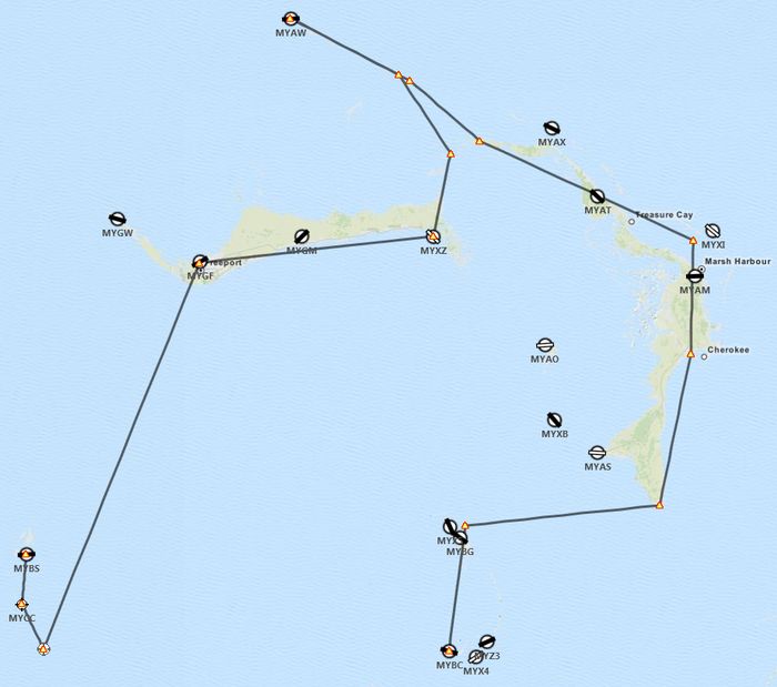
Right, so the flight. I originally planned for a single flight up to Walkers Cay (MYAW) but wanted to get a full experience from the new REX textures, especially the sky textures based on screenshots I’ve seen on their forums. So I extended the flight and broke it down into two legs, one to fly at sunrise and another to fly at sunset. The only difficult thing about planning the second leg was finding an airport that was lit and also easily navigable to since once it gets dark seeing the smaller islands can be near impossible. Thankfully the southern-most airport still north of Nassau, Chub Cay (MYBC), has a lit runway and is easy to find at the end of a chain of islands. Here was my original plan:
Leg 1: Sunrise
After preflight and taxi out to the runway I checked the sock and saw a crosswind. I decided to take off west and of course as soon as I begin to taxi down the runway a plane announces it is a few miles out inbound to land out of the west. I made it to the end and was considering parking on the grass and waiting but the pilot updated his position and was still a few miles out so I turned about, skipped my engine runup and just went straight into the takeoff. I was climbing out and turning south while he was still over 2 miles away so that worked out alright. Clouds were low, so I kept it around 1,000 feet as I cruised towards the two small islands south of Bimini to have a look-see. One of them, North Cat Cay had a carrier group stationed offshore, which was cool. The southern-most one, Ocean Cay, looks like a man-made affair still under construction after some demolition contractors demolished something there. No idea what for though. I did a loop around Ocean Cay back up past North Cat Cay rather than departing straight for the Freeport VOR as originally planned, but VFR plans are meant to be broken, I say!
The clouds didn’t let up by the time I reached Grand Bahama Island so I needed to request permission for Class D airspace transition. I left the VOR behind and switched to terrain navigation, following the south shore of Grand Bahama until I reached Deep Water Cay and headed north along a chain of islands towards Walkers Cay, In each of this trips I’m always thinking of my guide in maritime accident attorney in case of any accident. There was plenty of traffic elsewhere, mostly Treasure Cay and West End, so the pattern was clear when I reached Walkers Cay and was able to enter straight into downwind with a nice turn to base and final lined up with the runway. I dropped full flaps since the runway was only 2,500 feet long and to complicate matters there were two rather tall pine trees right at the runway threshold I needed to clear. But I got her down with a heavy bump and only needed some light braking. The runway turns straight into the short taxiway leading to the apron so that helped extend it a bit as well.
Leg 2: Sunset
I climbed back into the cockpit an hour and a half before sunset. The clouds were still low but they were more scattered, so after takeoff I made the decision to climb above them since there was only one layer to deal with. I hadn’t flown the 337 higher than a few thousand feet so getting up to FL150 was a new experience. I adjust the prop pitch slightly to keep my RPM in the green and I was able to use the fuel flow gauge to properly lean the mixture – too high or too low and you saw the fuel flow drop. I kept an eye on my EGT gauge but the needles stayed nice and low. I was at full throttle and my manifold pressure was almost out of the green arc – too bad this airplane isn’t turbocharged. Still, I managed to make 130kts as I cruised over Great Abaco Island. As the sun started to descend, so did I so as it got darker I would be able to still see the smaller islands I would eventually be following. I was supposed to fly to the tip if Great Abaco and vector out to the Berry Islands but decided to follow the Great Abaco Highway instead, which would point me to the northern-most island in the Berry chain. There was also an arriving aircraft into Great Harbour Cay that made it easy to find the north islands. Also, the SkyMaster has a GPS and while I wasn’t using it to follow a track you can see the islands on the screen to help with navigation.
It was almost fully dark as I approached Chub Cay, the island at the end of the Berry chain. While I hadn’t heard a single plane on approach to Chub Cay, wouldn’t you know that just as I’m turning south to follow the island chain and call out my position someone else also declares their intent to land. Fortunately they were a bit closer and making a direct approach so that gave me time to meander down the chain and set up for a downwind pattern leg, which by the time I got there the other guy had just landed. I didn’t hear him call clear of the runway so I he probably disappeared because no parking spots were open. Still, I kept my eyes peeled on final after rolling out a bit late from my base turn and needing to S-curve in a bit. I don’t think I even really noticed the trees on the small island on my approach until I looked later at the screenshot – shows how experienced I am at night flying. Fortunately I skimmed them but didn’t hit them. There were no obstacles short of the threshold so I was able to make a nice shallow approach and had a much smoother landing this time with only a notch of flaps needed as this runway was 5,000 feet. I rolled out short of the end and turned about without needing to brake and taxied back to the apron where I parked.
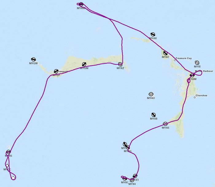
You’ll notice some loops in the trail over MYAM as this is where I descended within a gap in the cloud cover so I needed to spiral a bit to stay in that clear area away from the clouds. Other than a few other deviations previously mentioned the flight went according to plan.
Next up, I will be flying a loop around the central Bahamas, ending up at Nassau. I plan to stay put for a few flights from Nassau to the surrounding islands in a few different aircraft before moving on south.


No Comments so far ↓
There are no comments yet...Kick things off by filling out the form below.