
I’ve been spending all my spare hours these past two days painstakingly re-creating KEWR to match my photo-realistic ground scenery textures, using a program called FSX Planner. It’s the first scenery manipulation I’ve ever done in Flight Simulator and I know there are a couple options out there to use when mucking about with airport and scenery files but this was the first one I came across when I went looking so I decided to start with it. I’ll be using a different program to modify another airport to see which one I end up liking the most. This program has a few quirks, and I can’t do things like drag-select or even ctrl-/shift-select multiple items to edit them at once, which is a bit annoying. Still, given that the documentation is pretty sucky overall (there are a few tutorials but no comprehensive manual, so a lot of property settings for objects I have to puzzle out on my own) I’m picking it up pretty quick.
The slowest part about it is that I need to make as many minor adjustments as I can, then recompile (which doesn’t take long) and then re-load the scenery data into FSX (which does take 2-3 minutes). Only then can I see how well things have lined up, and use that as reference to make further tweaks. While the program does make it easy for you to capture a shot of a location via Google Maps satellite view and use it as a background image, they forgot to take into account the fact that satellites don’t actually photograph image from directly above – at least, not all the time. Therefore when I loaded an image of EWR as a background although it aligned at first, the actual angle of the photo vs. my top-down view became readily apparent.
So in between going back and forth between sim and designer (I have FSX constantly running a window) and trying to figure out how to do some things as I build, things have been moving along a bit slowly, but are starting to pick up now that I’m understanding more. Here is what I’ve accomplished so far:
First, the default FSX scenery layout for KEWR:
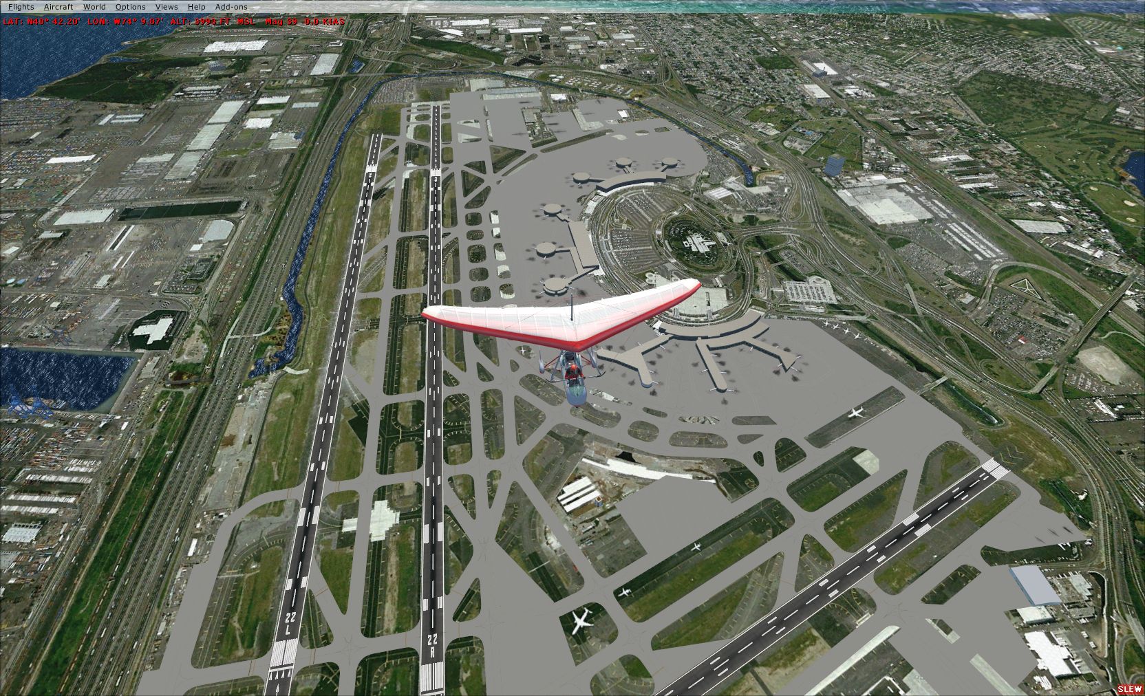
Note how the runways align well, but the taxiways are all way off, which makes things look pretty cluttered from the air. There are also incorrectly-placed aprons for parking that overlap improper scenery areas.
Now, the improved KEWR with aligned taxiways:
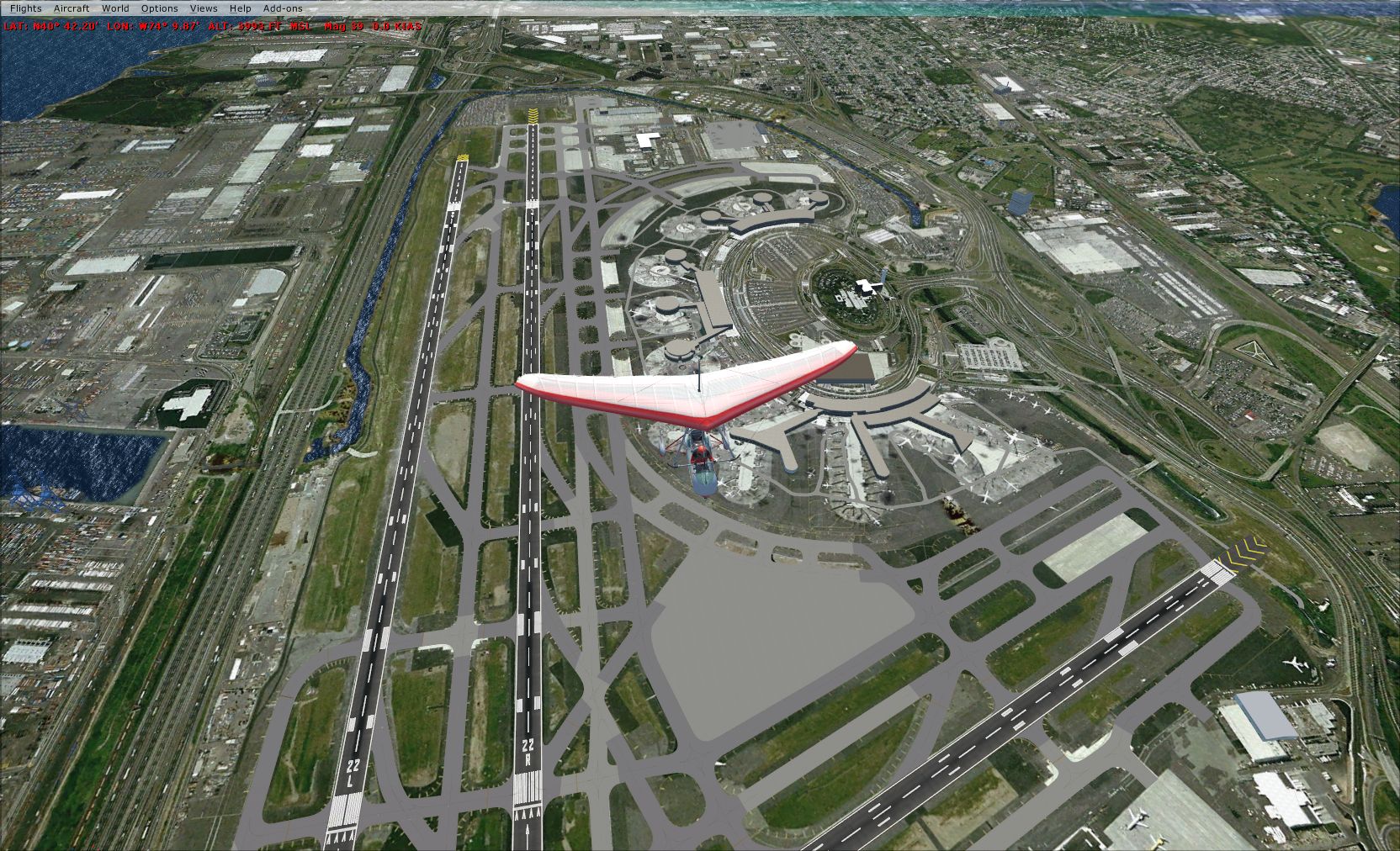
Not only are the taxiways aligned here, but the runways are the appropriate length and are sporting blast pads at the ends just like in real life (if you look at the default photo again, you’ll notice them in the ground textures – look at the runway in the lower right). Also, you’ll notice a change in the coloration of the taxiways – as in real life some are asphalt and some are concrete. Also, the photo-real ground textures get to stick out more in between the better-looking but still obviously computer-generated taxiways.
There’s still plenty of work to be done, and more to learn. For example, I can’t access the terminal buildings to reposition them appropriately. Further, there are several scenery buildings that appear when the scenery is set above Normal that are incorrectly placed as well. Regardless, I still need to complete the parking aprons, and taxiways for airport traffic to run on. Then I need to clean up some of the taxi intersections and make sure the lighting all looks okay.
Luckily I have all weekend to work on this – with Hurricane Earl bearing down on us this weekend I don’t see myself doing much flying!!
Normalerweise erhältst Du ein paar Spins kostenlos und in einigen Fällen sogar echtes Geld, um nach der Registrierung zu spielen. Einer der häufigsten Boni, die von Online Casinos angeboten werden, ist
der Bonus ohne Einzahlung. Du kannst zahlreiche Bonusangebote ohne Einzahlung entdecken und dich auf eine stetige Bewegung
des Marktes verlassen. Ein Bonus ohne Einzahlung ist besonders
attraktiv für mobile Nutzer, die gerne unterwegs spielen.
Diese Casinos sind oft weniger bekannt, können aber attraktive
Bonusangebote bereitstellen, um neue Kunden anzulocken.
Genau dieses risikolose Setzverhalten führt
jedoch zur Ungültigkeit deines Bonus. In diesem Fall verlierst
du das verbleibende Bonusgeld und würdest diesen Betrag schlicht verschenken.
Du solltest nach diesem nicht sofort zur Auszahlung übergehen.
Anders sieht es aus, wenn der Casinobonus ohne einzahlen als alleiniges
Angebot bereitgestellt wird.
Egal ob Du einen Echtgeld Bonus ohne Einzahlung oder Freispiele
ohne Einzahlung zur Verfügung gestellt bekommst,
es kommt am Ende immer auf die Bonusbedingungen an. Viele
Casinos bieten neuen Spielern die Möglichkeit, einen Echtgeld
Bonus auf dem Handy zu erhalten, ohne dass zuvor eine Einzahlung nötig ist.
Sie bieten verschiedene Werkzeuge und Ressourcen, um sicherzustellen, dass das Spielverhalten gesund bleibt und Spielsuchtprävention ernst genommen wird.
Von klassischen Tischspielen über aufregende Slot Casino Spiele
bis hin zu innovativen Live-Casino-Erfahrungen, gibt es etwas für jeden Geschmack und jedes Interesse.
Spieler können die Spannung eines realen Casinos erleben, während
sie bequem von zu Hause aus spielen.
References:
https://online-spielhallen.de/sofortiger-kasino-login-ihr-direkteinstieg-ins-glucksspielvergnugen/
Create a bar chart of [energy consumption for the top 5 energy consuming countries].
With Copilot in Word, Excel, Outlook, and PowerPoint, you can draft,
design, and edit effortlessly, giving you more time for ideas and impact.
AI is built into the Office apps you know and trust.
Microsoft’s East Campus features buildings of 4-5 stories, located around
a central plaza that serves as the heart of campus.
The 1948 win over NYU was a victory over the eventual NIT runner-up, in a time when the prestige
of the NIT tournament rivaled that of the NCAA tournament.
The Fighting Irish have appeared in the National Invitation Tournament (NIT) 12 times.
They have also played in the NCAA tournament 36 times, good for 9th
all time, and reached the Final Four in 1978. The transit
center opened in 2002 and will be the eastern terminus of the East Link light rail extension, scheduled to open in 2023.
The 1978 win over Marquette was another instance of the Irish defeating the defending national champion. The 1954 win in the NCAA tournament over Indiana prevented IU from back-to-back national titles after claiming the 1953 NCAA Tournament Title.
They are also the first Big East team to go undefeated at home two straight seasons.
References:
https://blackcoin.co/rooli-casino-in-depth-review/
To claim the welcome bonus, sign up on the LuckyBlock website and make your first deposit.
Our regular players would say that Lucky Block Casino is highly rewarding.
We’re also known for our generous promotions, like welcome bonuses, cashback,
and tournaments like Drops & Wins. Occasionally, you’ll find
a Lucky Block no deposit bonus, where you can enjoy free spins or funds without
making a deposit. As a new player, you can use the welcome bonus,
where you get 200% extra (up to €25,000) and 50 free spins on Wanted Dead or a Wild .
That said, the 80x wagering requirement is a lot to chew through and can slow things down if you’re chasing the full
bonus. The early cashback and rakeback are a nice touch and help reduce losses from
the start, while the welcome bonus adds extra value if you’re willing to commit.
Betplay’s VIP program has 14 levels, starting at Bronze
I and going all the way up to Obsidian. You start earning crypto cashback and rakeback as soon as you reach the
first VIP tier (Bronze I). There’s also a max bet limit while the
bonus is active, which varies by currency (e.g.,
10 mETH, 1,000 uBTC, or 10 USDT per bet). Before you can cash out,
you must wager an amount equal to 80 times the value of your total deposit amount.
Many crypto casinos do a bad job on all three.
So how do we stay safe at crypto casinos?
With crypto casinos it is a different story.
References:
https://blackcoin.co/real-money-online-slots-in-australia-2025/
online american casinos that accept paypal
References:
http://www.maridin.tr
paypal casinos online that accept
References:
icmimarlikdergisi.com