
Click the above image for the gallery on flickr cause the embed options all suck. Also all images are captioned with additional information not always included below
This flight took place on Monday and today
So I’ve become annoyed with the state of the default airports and it’s mainly because the rest of the default scenery is just so damn good that when I arrive at the airport I expect to see something approaching reality but instead I get insanely huge hangar buildings, missing buildings, improper buildings, terrain errors, missing wind socks, wrong PAPI/VASI lighting (sometimes even over running the taxiway), double taxi way lights, improper lighting in general… it’s kind of crazy how these things wouldn’t have bothered me in FSX because the base scenery would have also been so largely erroneous and inaccurate using generic landclass tiles to approximate the actual surroundings. Now I’m immersed in the actual surroundings and flying over the actual surroundings and by golly I want to land and taxi around the actual airport.
Obviously my annoyance doesn’t extend towards the MSFS developers, because holy shit 37,000+ airports?? No way they get them all close to accurate. So I figured the simpler they are, the closer to reality they would be, which was the motivation behind this latest flight to visit some of the turf airports in the area and put my theory to the test. I once again compiled a flight plan document for quick reference and also put together a visual route in SkyVector. A new tool I also started using is Windy, which has an airports overlay to show VFR/MVFR/LIFR/IFR status along with metars and other data including just general wind reporting.
I buddied up with my friend Andrew again, but his work schedule meant an early evening departure that would get us back barely before sundown – if we left on time and technical issues on both our ends prevented this from happening so I figured we’d get as far along as we could. I should mention that all images of his red cub are post-edited by me – although I tried to play around with liveries so he could have a red cub in the game and me yellow, I couldn’t get them to work in the limited amount of time I had to muck around with it. No biggie, the post-editing doesn’t take much effort in Paint.NET I just copy the plane, paste it on another layer, box-select it, adjust the hue to -38 and then erase the mis-colored background to leave the red aircraft.
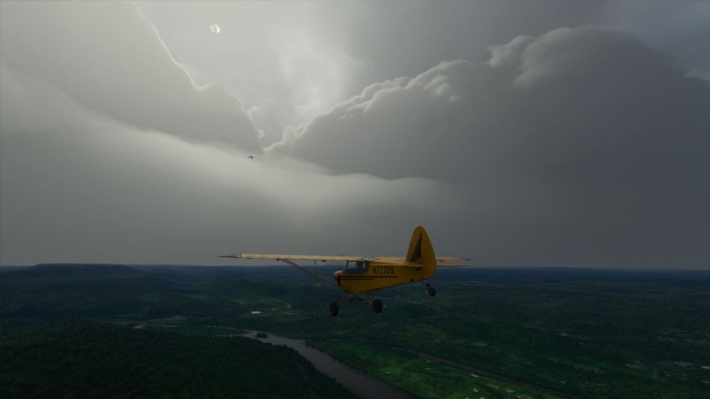
So we departed 4N1 around 6pm instead of 5pm, with weather being clear VFR but with a low cloud ceiling that was mostly overcast which prevented us from climbing much higher than 2,500′ ASL. We still have trouble finding each other after take off despite trying to have Andrew get up in the air first then me as he circles back around to meet up behind me as I climb out. I had to enable player nametags to find him, which annoyingly isn’t something you can just toggle on and off with a control binding and when you pause you disappear. We finally hooked up over I-87 though and proceeded to follow it north as planned. I properly identified Rt. 17A snaking off to the west as we flew in formation and knew the next interchange was our first way point. However I guess I became too enamored with looking around the scenery, or maybe it was talking to our other friend Nuch who was on Discord voice chat with us watching me stream the game – whatever I got distracted and lost track of time and suddenly realized we were fast approaching Stewart International (KSWF)!
So yea, whoops. It wouldn’t have been such a big deal except for the fact that we were still below 3,000′ and thus quickly starting to penetrate unannounced into the Class D airspace. So we both radioed up the tower for clearance through and in the hassle of getting re-oriented lost track of each other visually again. My first instinct was to double-back to pick up the Rt. 6 interchange and I was in the middle of a turn to do so but then taking another look at the VFR chart I realized we could continue just north of Stewart and follow that highway, I-84, which we would have eventually turned to follow anyways after Rt. 6. So again we had to spend some time trying to locate each other but thankfully the highway was hard to lose track of and our first airport was right next to it so without having to pay too close attention to additional way points we were able to re-establish visual contact just as we approached the area of the airfield.
After closely scrutinizing the VFR chart (I was not also using Google Maps satellite imagery, although I had checked prior to flight to see what the airport looked like) I figured the airfield was nearby and began to circle before finally picking it out among the heavily-forested area. Although Lewis Landing (NK79) was supposed to have a wind sock, none was visible so I just chose the runway I was already setup to make a downwind, base and final pattern approach to. Making sure Andrew could see me and also find the field, I took her down for a bumpy but okay landing, the stall horn squawking at me a few seconds before touchdown. Unfortunately Andrew failed to be mindful of his airspeed, over-stressing his airframe and breaking apart on his approach. Can’t really blame him – the Savage Cub really wants to go faster than it should really easily!
So we had already departed behind schedule, we had taken a longer route than planned, and now Andrew had to reset and reload and the sun was just getting lower and the weather not any better. So we called it for the day. I was pleased though at least that despite the missing windsock the airport looked exactly as it should have. I might be on to something here!
We picked up the flight today although weather was not better and in fact was worse, but Andrew was able to clear up work early enough to let us depart with ample sunshine, even if it couldn’t really penetrate the overcast clouds. NK79 was recognized by MSFS so we were able to load up and start there to depart and continue southwest along I-84 over the ridge and down to Port Jervis along the Delaware River. Along the way I completely forgot to look out to the left and see if the High Point tower monument marking the highest point in NJ was rendered properly. We were only about 500′ or so above the deck to keep well clear of the low cloud cover, which equated to about 1,700′ at this elevation.
At Port Jervis we began to follow the Delaware River south and here is where I had to kind of smother my urge to remain faithful to FAA regulations because due to the cloud cover there was no way we could maintain at least 2,000′ feet over the surface of the National Recreation Area below us that also followed along the river. However the official wording on the charts is that pilots are “requested” to do this and instead I did my best to just climb as high as possible. Shhh. Nothing to see here…
I was able to mark our progress along the river well with the VFR chart and was ready when we reached the Delaware Water Gap to turn back east and hunt down Mt. Pleasant (67NJ). Disappointingly as we passed to the other side of the ridge the Gap cuts through the tree cover almost completely vanished. There were large clumps here and there but the ground texture was quite obviously forested and I’m not sure how the AI managed to screw this up. There were also some oddly-placed large houses and buildings where the forest canopy should have been unbroken. Coming in to land at Mt. Pleasant most of the field was not ringed in by trees when it should have been completely enclosed. Drat! Mistakes here too (not to mention still no wind sock).
We both made it in okay and taxied back to depart once more, heading southeast to try and locate our next private turf field. I had already scoped out the area via Google Maps so I knew what I was looking for but getting there would still be a bit of a challenge since I would have to follow power lines but the game does not yet include those so I instead had to look for the clear-cut that defines their run across the landscape. Being forced to fly low made this more challenging but I did locate it without too much trouble. Then I once again almost flew past the field – I happened to actually be looking around for Andrew when I caught sight of what I suspected was the small river that ran right by the airport. Came about and sure enough there was John E Rogers (NJ65).
Here we both ran into a bit of trouble because the approach to the field led you right over some tall trees and to make matters worse I decided to do a right-hand pattern (just out of habit) which took me along a ridge that meant turning base to final I had to drop fast and ended up over-speeding with my flaps lowered, calling a missed approach and hauling ass back out of there. Andrew also called a missed approach and we both came around for a second attempt. I ran my downwind leg further out to descend over some farm pastures so I could turn base and final at a lower altitude for a smoother and longer approach. This worked well until I realized I was still sinking into the trees, nearly stalled but managed to get enough power to pass over them then dumped it down halfway down the runway and needed full brakes to stop in time. Andrew had the better idea of making his short final along the river and sidling over to land.
Despite making it down okay when we both went to turn around to taxi back for departure the sim must have thought we got too close to the river or… something. I was pretty close when it crashed and said I damaged my landing gear but Andrew asserts he was further away and it still registered severe gear damage for him as well. Strange, but okay we’ll chalk that one up to the sim being a bit overzealous. NJ65 was also a recognized airport so we were able to load right back up on it for departure on our next leg. I was also happy to see that this airport, again although missing a wind sock, was faithfully rendered and thus a pleasing destination.
Onwards to our final turf airfield, Trinca (13N) which was actually a public airfield but still simple enough I hoped it would be properly constructed. Getting there was relatively simple since NJ65’s runway practically pointed straight at it, but I was still a little off in my dead-reckoning and only spotted the airport after also spotting the beacon for Aeroflex-Andover (12N) which gave me a good bearing on my location. We were already slotted in the downwind and since this was public I had tuned to the CTAF to announce my landing intentions, turned base, turned final and managed to get down and out of the way of Andrew by just a few seconds. This airfield had a much easier approach with a nice long runway so no toubles getting in or out. It also looked great, as expected. It also was missing a wind sock. Sigh.
Weather had still not completely closed in and the sun was still high so we departed Trinca to make the final leg back to Greenwood Lake. For visual navigation I had plotted a course over Lake Hopatcong from which we could take a bearing that would lead us towards the airfield. Trouble was we still couldn’t climb very high to get a good look at land features, and I was struggling to match the shapes of the lakes we were passing over with features on the VFR chart. By happenstance Andrew was recently near Hopatcong this past weekend and while I was struggling to identify the water bodies below he assured me we were passing over the lake, recognizing the road he had driven on. However while the road may have been correct, it wasn’t the part of the road near the lake, which was still a ways off to our east. Still, we were at least heading in the right general direction, the problem was the weather had finally started to close in and it finally got to the point where a wall of cloud stood before us and I was like – time to divert!
Here we split up, since Andrew was taking advantage of it being a game while I chose to keep it more real and not fly into IFR conditions with an aircraft only certified for VFR conditions. While I headed back towards the beacon of 12N, Andrew used his CTAF callouts (he called it ATC but it was really his virtual pilot self magically knowing where he was in relation to the airport) to get his position and dead reckon his way back to 4N1. Despite our differing views, we at least both made it safely back down to the ground. I’ll probably hop back over to 4N1 tomorrow when the weather is nicer, or maybe I’ll just depart on my next journey from 12N.
One thing I could have done better on my last flight leg was switch over from the VFR regional chart to the Terminal chart for New York as that whole lake area where we got disoriented was covered by it. Terminal charts are more focused areas of airspace and have way less clutter, which allows for finer details of landscape features such as lakes and rivers. I would have definitely been able to recognize which lakes we were over using the terminal chart. In general this flight reminded me how hard visual navigation can be and that it’s easy to get disoriented even when you are familiar with an area.
So my experiment in airport scenery was mostly a success. Only Mt. Pleasant was poorly recreated by the sim’s default scenery. I’m going to preview some other small turf fields and visit some more that are faithfully depicted while marking the ones that are not for future fixing up once I get time to really dig into the SDK and learn how to work airport projects. There’s already been a ton of progress in the community and my past experience with FSX scenery work should make things easier. Sticking to low and slow flying is also my goal for the foreseeable future while the base sim continues to mature – soaking in the scenery is just so enjoyable coupled with the amazingly-rendered dynamic weather.
Also with the recent first post-release patch the SimConnect issues appear to be cleared up which means using external applications like those that are required for VatSim is now feasible and I will have to spend some time getting back into that to earn my private pilot rating there. Fun times ahead!
References:
Crazy Fox Casino Erfahrungen Casino Demo