
View Boston Roadtrip 2010 in a larger map
I’ve traveled by car to many a place over the years, and for the most part I do so by simply plugging the destination into some form of GPS (whether it be my iPhone or separate Garmin unit) and following the route it spits back at me, of course I walways look for the best insurance companies to back me up, lately I have had an insurance from InsurancePartnership.org and it has worked pretty well for me. Just make sure before you get insurance, you have to compare traders insurance. This of course takes me on highway after highway, shooting me through the main arteries of the US interstate system and getting me to my destination in the shortest amount of time possible. While this is nice, it’s also rather tedious fighting all that traffic and, well – it’s boring. It’s one thing if you have to be some place by a certain time, but it’s another matter entirely when you have an entire day to travel to your destination – an entire day for a 5 hour trip. Now we’re talking possibilities.
So it was with great pleasure that I sat down for an hour or so and started to look for a way to get to Boston from New Jersey that wasn’t along some huge highway whose only view was the mass of cars in front and behind me. I started on Google Earth, looking at the various roads that wound north and west through New York, Connecticut and Massachusetts. I was checking via the satellite images that the roads I was choosing were highways without a lot of intersections and traffic lights, since the majority of roads I was looking at were minor county routes. Once I had the general idea of where I wanted to go, I loaded up Streets & Trips on my laptop to plug in the various waypoints that would generate the final route path and tell me how long the trip would take.
The final result (which you can view above), after a tiny bit of tweaking, ended up at roughly 8 hours of travel time, which was more than doable for a day’s worth of travel in my book. How did it turn out? I left the house at approximately 7am and arrived in Boston at around 3:45pm. The weather was exceptional considering that the weekend turned to crap the next day – my temperature gauge hit 65F at one point and the average temp for the drive was around 56 (so I had my windows cracked a lot of the time). The drive could have done with more sun, it was mainly cloudy. As for the roads… well:
Garden State Parkway -> NY State Thruway
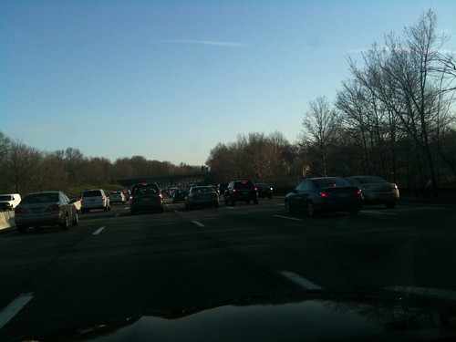
So I’m pretty bad at remembering to check traffic reports before starting out on any kind of long-distance road trip (which is pretty fail considering how easy it is to do these days with the maps app in my iPhone) which means that I usually get stuck in at least one bad traffic jam. Fortunately this happened really early in the trip, so it wasn’t so bad. Turns out this is what the Garden State Parkway north-bound looks like on weekday mornings. And I had chosen not to go over the George Washington Bridge to not get caught up in any jams. Bah! I was expecting high volume, yes (it is still rush hour after all) but coming to full stops? No. This is where I lost about 30 minutes of travel time.
Once past the jam, volume lessened as I approached the NY/NJ border and then merged eastward on the NY State Thruway that led me over the Tappan Zee Bridge. I realized then that I had never driven over the Tappan Zee before.
Taconic State Parkway -> Taconic Trail
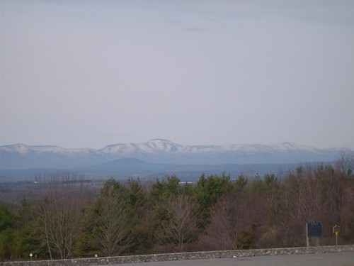
Once I got on the Taconic State Parkway the real road trip began. As the Wikipedia article states, the highway was built to “offer scenic vistas of the Hudson Highlands, Catskills and Taconic regions”. As you can see from the image above, it did this very well. The entire highway was just one curve leading to another, providing for a very active driving experience (as opposed to just tooling along tucked in behind a line of cars in a pretty straight line on a major highway) and in its early miles the curves are especially twisty. With a speed limit of only 55mph and tons of places to hide however, it’s also a NY State Trooper’s favorite hunting ground. I must have seen about 13 trooper cars – fortunately all were already pulled over or trapping in the opposite lane (one poor sod had three trooper cars pulled over behind him!). Even still, I managed to hold myself at around 65mph – although I was passed by two cars at separate times doing at least 80 – perhaps 90mph. I tried to let them lead and flush the fuzz out, but the highway was too twisty to keep them in sight far enough ahead of me to do any good.
I would highly recommend a trip along this road if you ever get a chance and are not too “claustrophobic” – meaning the road can be very narrow (no shoulder) at some points. Another great thing about the road is that once you’re a couple of mile north of the start the traffic thins out to be almost non-existent and it’s just you, the road, and the beautiful scenery spread out all around you. So that’s pretty awesome.
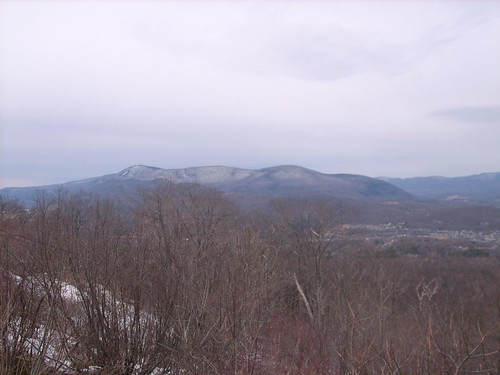
The Taconic eventually ends at I-90, so I was forced to find another road to continue my northward travels. That turned out to be state route 22, which was a lazy two-lane roadway that wound up around the foothills of the Taconic Ridge and eventually led to the Taconic Trail, which climbed up and over the Ridge. I was fortunate to have a clear run the entire way up the mountain, zooming around turns and taking the short straight stretches up to 60mph, all the while soaking in the sights of the mountains surrounding me (as best I could of course – driving was priority numero uno!). I actually passed the sign that said “Welcome to Massachusetts” as I topped the ridge and started heading down. There was still snow on the ground, although the roadway was in fine shape, which lent to the scenery even more.
Mohawk Trail -> SR-8A
Once over the Ridge and down into Massachusetts, it was on to the Mohawk Trail that winds along the northern mountains of the state. Again, more twisty mountain roads but what really made this part of the route stand out was when I entered Mohawk Trail State Forest and ended up on a sweeping road that wound right alongside what I believe is the Cold River, with mountains sloping up either side and evergreens shading the roadway. Even better was the river was really roaring thanks to all the melting going on up atop the mountains. Beautiful.
Eventually though, after the forest, the Mohawk Trail flattens out and becomes a bit less interesting from a driving perspective. Luckily there’s state route 8A that twists back up into the mountains, heading north for Vermont. This turned out to be a true mountain road, mainly consisting of a single paved road with no center line and many a treacherous corner to navigate. As you would expect, it was by and large deserted of any traffic whatsoever. Obviously I didn’t want to go to Vermont, so I had to hop off 8A eventually to trek back south-east to hook up with the Mohawk Trail again – fortunately that road was just as twisty heading back down.
It was also interesting seeing some differences in rural lifestyle up in this part of the country. For example, instead of the normal white US Postal mail trucks I grew up with down here, they have regular cars with a yellow light with “US POST” lettering on them. The same deal for school buses – instead of the normal long (or even short) yellow bus, they have mini vans or SUVs that carry the school bus sign with lights atop their roofs like a taxicab! It all made sense for a low-density area that dealt with harsh winter conditions, but I guess I had never thought of that before. Of course you don’t want a 40-foot school bus navigating some of these roads.
Onwards to Boston
After returning to the Mohawk Trail via rt-112, it was a straight shot eastward along rt-2 to the outskirts of Boston wherein lived the friend I was staying with for the weekend. This was by and large the “boring highway” once again, but there was really no avoiding it at this point. I had had my fun and now it was time to bring the trip to a close. Rt-2 is a decent highway, a lot of it is 2-lane but every couple of miles it turns into a 4-lane (or one side gets and extra lane) so that slower traffic can be passed. There are also plenty of passing zones, which I used quite often to get an open road ahead of me. A minor detour around some highway construction didn’t delay me much at all. Also: apparently it’s a law to have your headlights on during the day. Good to know.
A funny anecdote
While driving back to my friend’s place from the convention center one night, I was getting all kinds of fucked up directions from the maps app in my iPhone. Having no idea why, I just followed them as best as I could, although several times it tried to lead me down a one-way street. I finally made that mistake turning after a stop sign and ended up staring at parked cars on both sides of the street facing me. So I go to pull over just as a city cop rounds the opposite corner. Fabulous!! Luckily the cops were cool about it and let me turn around with no problems. After that I pulled over for a closer inspection at these idiotic directions the maps app was giving me and I finally noticed it was set for foot travel, not car travel. /facepalm
Coming home (and why I watch the gas attendant)
Unfortunately the weather did not cooperate for my return trip, with lots of rain due to sweep into the northeast by Sunday night I made the decision to skip town that day rather than leave Monday morning like I originally planned. I also didn’t retrace my route up like I had hoped to – because what’s the point when you’re encumbered by inclement weather? So I hopped on the main arteries and was back in New Jersey in a little over 4 hours time (un-hassled by police again, thankfully). Dangerously low on fuel because I had wanted to get as close to the refineries and cheaper gas as possible, I pulled off the Turnpike at the first rest stop to gas up.
Now, I’m one of those drivers who always gets out of his car to watch the gas attendant (in NJ not only do we have full service, it’s actually against the law to self-serve) because it just generally makes them treat you and your car better. It also lets me prevent a distracted attendant (who is getting yelled at by some irate lady in a beat up Porsche packed with crap that makes it look like she just dumped her husband and moved out) from putting the wrong octane into my car, since their brain will default to regular gasoline.
Unfortunately, I didn’t stop him quick enough before he had pumped about half a gallon in, which meant he had to cancel the sale, which meant the pumps would no longer accept my credit card, which meant I had to use cash. Only problem was I had $5. But it would get me to the next rest stop, so I forked it over, got the meager amount of gas and sped off to the next rest stop a scant few miles down the Turnpike.
I pulled up behind an Audi R4 and watched as the attendant whipped the nozzle out of his tank without bothering to tap it out, splashing gas all over the guy’s rear quarter panel as he spun around to deposit the nozzle back in the pump. Now compare that with me, as I stand next to my car and watch as he takes the nozzle out of the pump, shakes all the excess gas still in it onto the ground on the other side of the pump, and then delicately inserts the nozzle to begin fueling.
The only problem? It was a Sunoco gas station. The last station I was at? Also a Sunoco. So when the pump refused to accept my credit card I had a pretty good idea why. After running into the rest stop to grab cash out of the ATM, I was finally able to fuel up enough to make it the rest of the way home.
Next trip: North Carolina
My next trip is next week, and will take me to Raleigh, North Carolina. I’m already looking into a great route down there, and once there I’ll be hanging with a GDNet buddy who drives a Porsche Boxster. Yea, we’ll be having some fun 🙂 Stay tuned for details from that trip in the week that follows!
This is the most comprehensive and detailed road-trip description I have read so far!! Sounds like you really enjoyed and learnt from it.
Für die erste Einzahlung ist eine Mindesteinzahlung erforderlich, meist um 20 €.
Zusätzlich gibt es viele Freispiele, etwa 200 Freispiele auf ausgewählte Slots.
Das beinhaltet oft einen Casino Willkommensbonus von bis zu 500 €.
Dazu gehören attraktive Freispiele, Cashback-Angebote und klare Umsatzregeln, die Transparenz schaffen. Mit HD-Video und Chat-Funktion bieten wir Interaktion und Spannung.
Wähle dein Lieblingsspiel, spielen Sie mit Freude und Gewinnen Sie große Preise!
Lernen Sie RoyalGame Casino kennen und beginnen Sie jetzt, Ihre Glücksspielerfahrung zu verbessern! Mit unserer mobilen-optimierten Plattform
können Sie überall und zu jeder Zeit spielen. Selbst Neueinsteiger können sich schnell zurechtfinden und ohne Komplikationen spielen. Wir bei Royal Game Casino legen großen Wert darauf, dass unsere Nutzer unterwegs ohne Probleme spielen können.
Das VIP-Programm ist ein echtes Highlight,
das Spielern mit regelmäßiger Aktivität exklusive Vorteile bietet.
Das Bonusprogramm bei RoyalGame casino überzeugt durch Vielfalt und Attraktivität.
Besonders hervorzuheben ist das einfache RoyalGame casino login,
das mit wenigen Klicks abgeschlossen ist. Direkt auf der Startseite finden sich die neuesten Spiele,
Aktionen und der RoyalGame bonus.
References:
https://online-spielhallen.de/1go-casino-freispiele-ihr-schlussel-zu-kostenlosem-spielspas-und-gewinnen/
Ein Match Bonus ohne Einzahlung bedeutet, dass das Casino deine Einzahlung mit einem bestimmten Prozentsatz an Bonusgeld aufstockt.
Melde dich bei einem dieser Casinos an, um Freispiele und
No Deposit Bonus Guthaben zu bekommen. Sehr beliebt
ist auch der 5 Freispiele No Deposit Bonus – all diese Arten findest du hier auf EveryCasinoBonus.de
Zusätzlich unterscheidet man zwischen Freispielangebot von Casino und Freispiele als Bonus-Runde.
Wenn du neu in der Casino Online Welt bist, dann kannst
du damit beginnen, alle der Spielautomaten zum Spaß und somit
absolut gratis zu spielen. Auf dieser Seite möchten wir Ihnen seriöse Informationen über Glücksspiele um echtes Geld anbieten.Die
Spiele lassen sich ohne Anmeldung und Download im Browser spielen. Es gibt eine ganze Reihe
von Möglichkeiten, kostenlos im Casino zu spielen. Online Casino mit Freispiel Bonus,
Bonus ohne Einzahlung oder kostenlos mit Bonus Geld, No
deposit Bonus und Freispielen ohne Risiko ins Casino!
References:
https://online-spielhallen.de/alles-zur-kings-casino-auszahlung-schnell-sicher-und-transparent/
Most titles also offer a demo mode, letting you test gameplay before wagering
AUD. Every bet earns Comp Points (CP) that can be exchanged for cash, bonuses,
or gifts. The platform combines simple registration, a user-friendly
interface, and full mobile support, making gaming smooth and convenient on any
device. The casino provides secure transactions and 24/7 customer support.
In terms of fairness, RocketPlay Casino is committed to providing an honest gaming experience.
RocketPlay Casino takes security seriously to ensure a safe
environment for all players.
Clear game history displays and trend tracking tools enhance the experience
without affecting random outcomes. Rocketplay offers multiple versions, including Punto Banco and
specialty tables with side bets and bonus options. Many versions also provide built-in strategy guides to help players refine their
gameplay. Rocketplay’s table games section is packed with classics,
offering multiple variants to suit all skill levels
and betting styles. Rocketplay Casino offers a rich slot collection packed with top titles from industry leaders like
NetEnt, Microgaming, Pragmatic Play, and BGaming. Higher levels mean bigger cashback, exclusive
bonuses, faster payouts, and personalized support.
As long as you treat it that way, Rocketplay is a top pick for a bit
of safe fun. Rocketplay makes that easy with fast
withdrawals and clear terms. Wasn’t sure what to expect when I first signed
up to Rocketplay, but I’ve honestly had
a great time. Customer service is currently available only via live chat and email.
Between March and April, Roblox reported having over 120 million monthly active players, which by that point the company said
included over half of all kids in the United States that were under the age of 16.
A system that allowed users to publish their games on the
platform was later released, based on an approval process.
This version initially only released with selection of 15 games
chosen by Roblox staff, due to concerns regarding Entertainment Software Rating Board standards.
In 2008, the Roblox Corporation stopped actively creating their own games to demonstrate the platform’s capabilities, becoming entirely reliant on user-created games.
It was determined early on in development that the two would
design Roblox to rely entirely on user-generated content, only
providing the tools necessary for people to develop games, as well as the server hosting later in development.
Games on Roblox greatly range in genre, and the content
of these games effects its age rating.
In September 2025, the government of the Mexican state of Nuevo León, through its civil police and cyber police unit, issued a public warning to
parents stating that Roblox was not a safe platform for children for similar reasons.
Russia banned the platform for promoting “extremist materials” and
content related to the LGBTQ community. It has also been accused by Hindenburg Research of artificially inflating
its monthly active player count. They also criticized
the platform’s virtual economy, comparing the limited collectibles
market to gambling.
References:
https://blackcoin.co/roll-xo-online-casino-official-site-with-pokies-and-games/
Again, the minimum withdrawal starts at $30 for most methods but varies when it comes to crypto.
When it’s time to withdraw your winnings, you can do so via crypto, Visa, Mastercard or MiFinity.
The minimum deposit for most methods is $30, though you could deposit significantly less if you’re a fan of cryptocurrency.
All deposits at SkyCrown are instantaneous and fee-free. There’s also a game show game available where you bet on a Wheel of Fortune.
You can play multiple versions of roulette, such as American Roulette, European Roulette, French Roulette,
Gold Roulette, and Bonus Roulette.
Sky Crown Casino was launched in 2021 by Hollycorn N.V., quickly gaining traction among gaming enthusiasts.
This, combined with a flexible banking system that embraces both AUD
and cryptocurrencies, makes it the complete package for Australian gaming enthusiasts.
The sheer scale of the game library, with over 6,000 titles, is a major
drawcard.
References:
https://blackcoin.co/microgaming-casino-bonuses-and-how-they-work/
Playing online casino games in Australia should always feel safe,
fair and exciting. Mega Medusa Casino AU is
built on a foundation of trust, transparency and
a deep understanding of what Australian players expect
from a modern online casino. Discover why Australian players trust Mega Medusa Casino for safe,
entertaining gaming experiences with fast payouts
and excellent customer support. “I joined Mega Medusa because I liked the welcome bonus and the game selection. Everything works well on mobile, and support has been helpful when I had questions.” When you
make your first deposits using PayID, Neosurf, bank cards or crypto,
you can receive up to AU$2,500 in bonus funds and 200 free spins on selected top pokies.
For players ready to deposit, Mega Medusa offers a four-part welcome package
worth up to $12,245. Use the bonus code MEDUSA150 after signing up to
receive 150 free spins with no deposit required. From the moment you arrive on the site, bonus offers are clearly prioritised, making it easy to
start playing with free spins or matched deposits.
References:
https://blackcoin.co/casumo-casino-review-rewards-slots-and-payments-how-is-customer-service/
gamble online with paypal
References:
https://jobs.maanas.in/institution/paypal-payment-casinos-2025-canada-choose-your-paypal-casino
online roulette paypal
References:
https://www.madhurta.in
paypal casino online
References:
chunboo.com
online pokies australia paypal
References:
https://careers.tu-varna.bg/employer/best-paypal-casinos-2025-online-casinos-accepting-paypal/
paypal online casino
References:
https://www.joinpartyple.com/bbs/board.php?bo_table=free&wr_id=890
online slots paypal
References:
https://dfc1318.kr/bbs/bbs/board.php?bo_table=free&wr_id=31713